CONNECT WITH US
OFFICE: (540) 985-0000
     27 Church Ave. SW, Roanoke, VA
BLUE RIDGE LAND CONSERVANCY
  • About Us
    • Contact
    • Where We Work >
      • Bedford County
      • Botetourt County
      • Catawba Valley
      • Craig County
      • Floyd County
      • Franklin County
      • Montgomery County
      • Roanoke Valley
      • Smith Mountain Lake
      • Other Areas
    • Education >
      • Bay Days & River Days
    • Staff and Board
  • Save Your Land
    • How To Save
    • Financial Benefits
  • Events
    • Conservation Celebration
    • Outdoor Adventures
  • Support Us
    • Become a Friend
    • Become a Sponsor
    • Shop to Save Land
    • Monthly Giver
    • Planned Gifts
    • Turn cars into land
    • Volunteer Today
    • Internship Opportunities
  • News
    • Job Announcements
    • Vic Thomas Environmental Stewardship Award
    • Land Saver Award
    • Saving Land Newsletter

Montgomery County

The region’s most populous county, Montgomery County is a rapidly urbanizing county, with growth spurred on by Virginia Tech and focused on the Blacksburg-Christiansburg corridor. The Eastern Continental Divide splits the county more or less in half, with the eastern half of the county draining into the Roanoke River and the Atlantic Ocean, and the more elevated western half draining into the New River and the Gulf of Mexico. A tiny portion of Brush Mountain drains into the James River basin.

Much of the northern portion of Montgomery County is part of the Jefferson National Forest, where recreational opportunities abound. The western portion of the county sits on a rolling plateau that is some 1,000 feet above the Roanoke Valley to the east. The New River, one of the oldest, most geologically interesting, and threatened rivers in the world, forms most of the county’s western border.

The Blue Ridge Land Conservancy protects about 440 acres of land in Montgomery County and more than 1.5 miles of the North Fork of the Roanoke River with two conservation agreements.


Picture
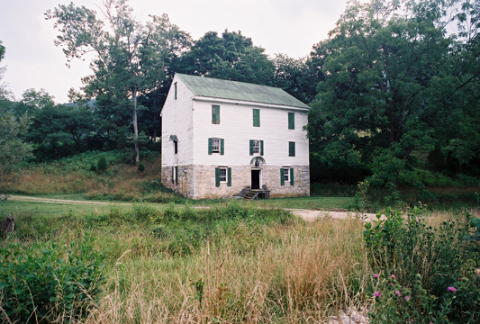
McDonald’s Mill along the north fork of the Roanoke River, protected with a conservation agreement by the Blue Ridge Land Conservancy and the Virginia Outdoors Foundation.
Picture
Picture
Picture
Quick Links
Home
Support BRLC

About BRLC
Staff & Board
Where We Work
Education
Saving Land Newsletter
Landowner Resources
General Resources

Contact Us
"We abuse land because we see it as a commodity belonging to us. When we see land as a community to which we belong, we may begin to use it with love and respect.” 
   
        ― Aldo Leopold
Picture
The Blue Ridge Land Conservancy  is a 501(c)(3) non-profit. We rely on the generosity of supporters to help us save the land they cherish most. 
©2016 Blue Ridge Land Conservancy, 27 Church Ave. SW, Roanoke, VA 24011 | (540) 985-0000